
NISAR radar images Mississippi River Delta through clouds
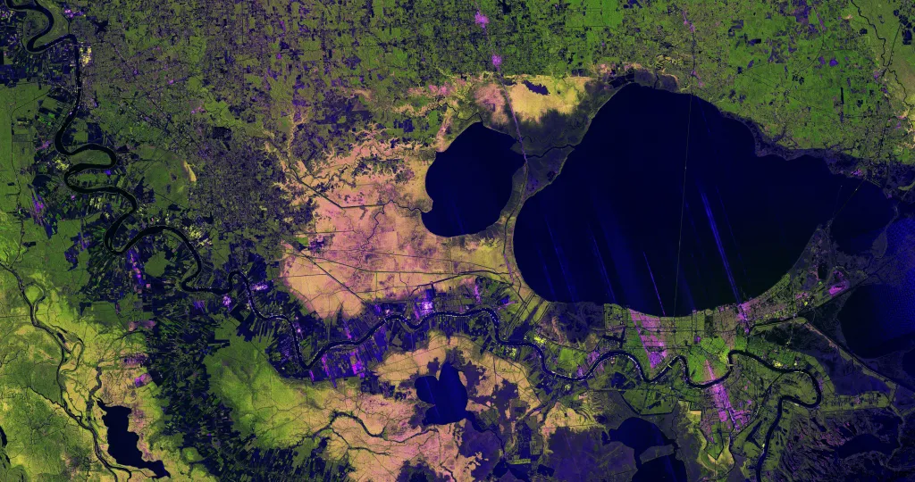
NASA and the U.S.-Indian NISAR mission released a radar image captured Nov. 29 that peered through clouds to reveal the Mississippi River Delta region in southeastern Louisiana, showing New Orleans, Baton Rouge, Lake Pontchartrain and surrounding wetlands and farmland, the agency said.
The image, created from L-band synthetic aperture radar (SAR) data, contrasts with optical imagery taken the same day that showed the region largely obscured by clouds, illustrating the satellite’s ability to image the surface using microwaves rather than visible light. NASA’s Jet Propulsion Laboratory–built L-band radar uses a 9-inch (24-centimeter) wavelength that can pass through clouds and distinguish land-cover types.
The colors in the image represent differing microwave reflections: portions of New Orleans appear green where signals scatter from buildings at varying angles, and magenta where streets parallel to the satellite’s flight track cause strong returns. The image resolution makes features such as the Lake Pontchartrain Causeway — described as nearly 24 miles (39 kilometers) long — clearly visible.
The satellite data show healthy forests west of the Mississippi as bright green, thinned tree populations in the Maurepas Swamp as yellow-and-magenta-speckled hues, and variations on riverbanks that suggest fallow farm plots (darker) and areas with tall plants or crops (bright magenta), according to the mission team.
nisar mission, l-band sar, mississippi river delta, new orleans, baton rouge, lake pontchartrain, lake pontchartrain causeway, maurepas swamp, wetlands and farmland, radar imaging through clouds, nisar sample data, jet propulsion laboratory