
Phytoplankton bloom encircles Chatham Islands east of New Zealand
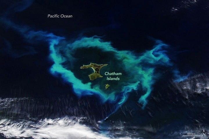
A ring of bright green and blue phytoplankton swirls encircled the remote Chatham Islands, about 800 kilometers (500 miles) east of New Zealand’s South Island, in satellite imagery captured on January 10, 2026.
The image was taken by the VIIRS (Visible Infrared Imaging Radiometer Suite) on the NOAA-20 satellite and published by NASA Earth Observatory as an Image of the Day on January 16, 2026. NASA credited Lauren Dauphin for the image, which used VIIRS data from NASA EOSDIS LANCE, GIBS/Worldview, and the Joint Polar Satellite System.
The Chatham Islands sit on the Chatham Rise, an underwater plateau whose relatively shallow top separates deeper waters to the north and south. Those seafloor contours, and the convergence of cold, nutrient-rich Antarctic currents with warm, nutrient-poor subtropical waters, make blooms common along the rise; well-mixed water and long daylight hours can boost phytoplankton populations.
Phytoplankton form the base of the local food web, and the waters around the islands support productive fisheries with species such as pāua, rock lobster, and blue cod. The region also hosts an array of marine mammals—including five seal species and 25 whale and dolphin species—and is noted as a hotspot for whale and dolphin strandings, in which hundreds of animals are sometimes beached.
Key Topics
Science, Phytoplankton, Chatham Islands, Chatham Rise, Viirs, Pāua